Southern California has some of the most diverse landscape and terrain in the world, and this makes it an ideal region to explore by way of a scenic drive. Over the course of an hour, afternoon, or even a weekend, adventurous travelers can feel themselves swept from the highest mountains, to the expansive desert, and even breathe in the salt air along the coast in just a short time. Although the routes full of wonders in Southern California are too many to count, here is a sampling of our favorite ways to tour the area:
No. 10 – Morro Bay Scenic Drive
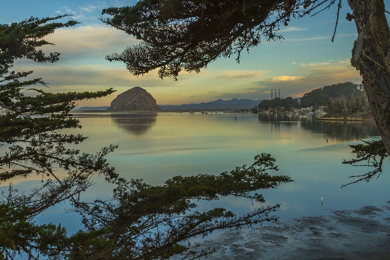
Starting Location: San Luis Obispo, CA
Ending Location: Morro Bay, CA
Length: 16 miles
Best Season to Drive: Spring
See this drive on Google Maps
This scenic drive is beautiful year-round, but travelers can see more colorful vegetation and people during the growing season. Birdwatching enthusiasts can also delight in several stops that afford views of egrets, herons, and other feathered friends, such as outside the Museum of Natural History off of State Park Road and at Windy Cove. The prime attraction, however, is Morro Rock, which is a short walk away on the boardwalk at the route’s final destination in Morro Bay.
No. 9 – King’s Canyon

Starting Location: Dunlap, CA
Ending Location: Kanawyers, CA
Length: 56 miles
Best Season to Drive: Spring, Summer, and Fall
See this drive on Google Maps
Nestled between the Sequoia and Yosemite National Parks, King’s Canyon passes through such delights as massive Sequoia trees, granite formations, and picturesque vistas. Travelers can seize photo opportunities with such attractions as the 3000-year-old General Grant Tree and canyon views from Panoramic Point. More adventurous souls may even wish to stop and climb to the top of Park Ridge Fire Lookout off of Forest Road.
No. 8 – Malibu to Lompoc
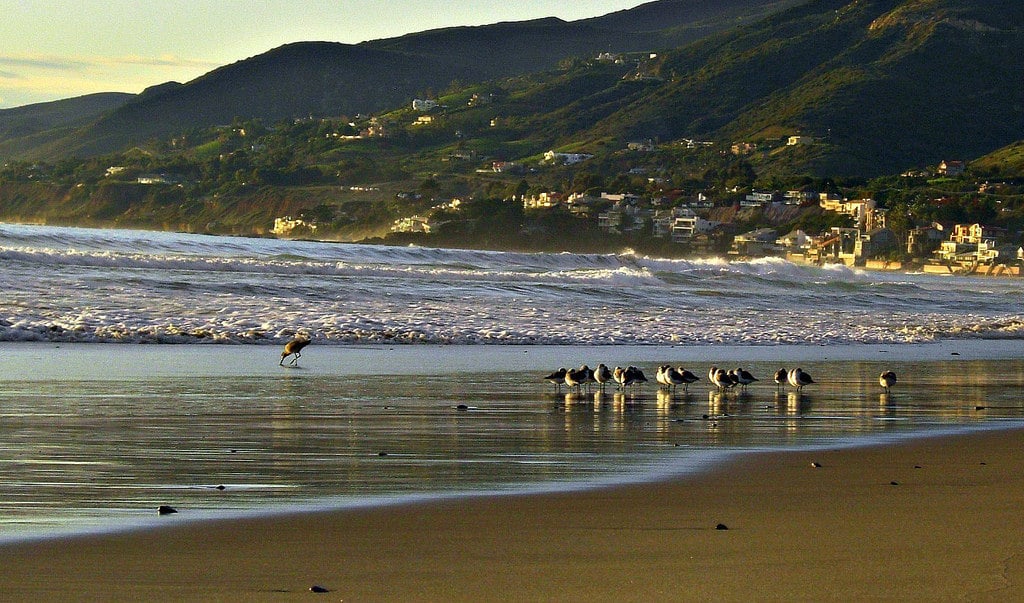
Starting Location: Malibu
Ending Location: Lompoc
Length: 121 miles
Best Season to Drive: All
See this drive on Google Maps
A trip starting from the spectacular Malibu Sport Fishing Pier has a lot to live up to, and the drive from Malibu to Lompoc doesn’t disappoint. The route hugs the California coastline, affording countless views of seabirds, surfers, and rolling waves. Notable attractions along the way include the Art Deco Point Hueneme Lighthouse, the wrecked La Janelle cruise ship, and the botanical gardens at Lotusland.
No. 7 – Anza Borrego Desert

Starting Location: East Entrance of Anza-Borrego Desert State Park
Ending Location: Ocotillo, CA
Length: 92 miles
Best Season to Drive: All
See this drive on Google Maps
As the largest state park in the West, exploring Anza-Borrego Desert State Park takes time despite the route being fairly short at 92 miles. The desert scenery, full of visually appealing rock formations and jagged horizons have no shortage of ways to entertain and enchant. The route goes through such places of interest as the Borrego Badlands, Seventeen Palms Oasis, and the Santa Rosa Overlook.
No. 6 – Joshua Tree Journey
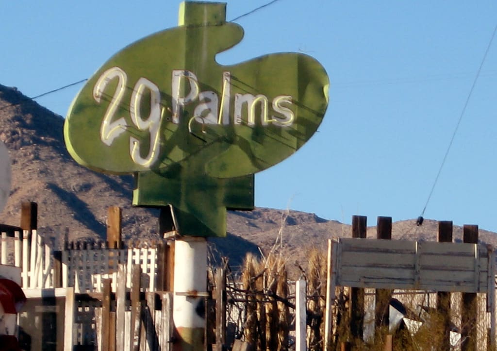
Starting Location: Palm Springs, CA
Ending Location: Junction of I-10 and Hwy 168
Length: 126 miles
Best Season to Drive: All
See this drive on Google Maps
As the name of this route suggests, there are numerous opportunities to view Joshua trees, which can live to be as old as 800 years, in the Mojave Desert. Driving along Twentynine Palms Highway, travelers can also take in other desert vegetation like barrel cacti and even a palm grove along with chance to glimpse local wildlife, such as spiny lizards and bighorn sheep. Hiking opportunities also abound for those willing to stop and explore.
No. 5 – Jacinto Reyes Scenic Byway
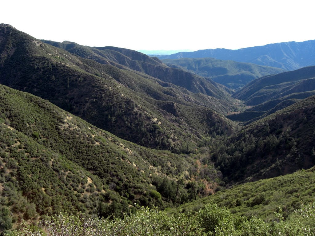
Starting Location: Ojai, CA
Ending Location: Ozena, CA
Length: 38 miles
Best Season to Drive: Spring, Summer, and Fall
See this drive on Google Maps
This winding, two-lane road trip passes through both the Los Padres National Forest and the Santa Ynez Range with sweeping vistas of the surrounding landscape at virtually every turn. The drive also provides glimpses of avocado orchards, Cuyama Badlands, and the Chumash Wilderness. To lengthen the relatively short trip, travelers can stop for a hike to Bellyache Springs just after the Wheeler Gorge Campground or take a slight detour on high-elevation Pine Mountain Road.
No. 4 – Rim of the World Scenic Byway

Starting Location: Phelan, CA
Ending Location: Mentone, CA
Length: 100 miles
Best Season to Drive: All
See this drive on Google Maps
This scenic byway that passes through the San Bernadino Mountains is aptly named because, with the road hugging the sides of steep terrain, travelers truly feel they are on the rim of the world. The elevation provides panoramic views throughout the drive and also provides aerial looks at Lake Arrowhead and Big Bear Lake. Stop at Heaps Peak Arboretum to learn about the native trees or increase knowledge of astronomy at the Big Bear Solar Observatory along the way.
No. 3 – Highway 111

Starting Location: Indio, CA
Ending Location: Niland, CA
Length: 58 miles
Best Season to Drive: All
See this drive on Google Maps
While this section of Hwy 111 rarely tops lists of scenic drives in SoCal, it is nonetheless worth the trip, especially for those with a photographer’s eye and skill. It runs along the Salton Sea and, consequently, provides a plethora of ocean views. Stop at the free camping area in Slab City to look at some truly inspiring graffiti, and don’t pass up the opportunity to take pictures of the abandoned structures at Bombay Beach.
No. 2 – Death Valley Scenic Byway

Starting Location: Olancha, CA
Ending Location: Death Valley Junction, CA
Length: 131 miles
Best Season to Drive: Fall, Winter, and Spring
See this drive on Google Maps
The extreme temperatures and ultra-low elevation of Death Valley has created a landscape unlike any other in the world. While travelers may not want to conduct lengthy explorations on foot, the Death Valley Scenic Byway allows them to look closely at its wonders from the comfort of their vehicles. Must-sees on the drive include the 6,433-feet high Aguereberry Point with sweeping views of the valley, Ubehebe Crater, and Dante’s View.
No. 1 – Big Sur Coast
Starting Location: Monterey, CA
Ending Location: San Luis Obispo, CA
Length: 141 miles
Best Season to Drive: All
See this drive on Google Maps
While any seaside drive is bound to be beautiful, words fail to describe the sights seen along the Big Sur Coast. The natural splendor abounds with waves crashing against white sand and occasional peeks at wildlife like sea lions, sea otters, and all manner of birds. In addition to what Mother Nature has provided, this route begs for travelers to stop and explore places like the village of Carmel-by-the-Sea, numerous lighthouses, and even Hearst Castle for a truly royal treatment.